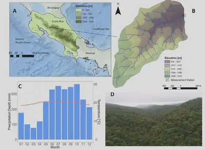
Reserva Biologica (ReBAMB), Costa Rica
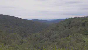
The Reserva Biologica Alberto Manuel Brenes (ReBAMB) is an 80 km² protected biological reserve of primary humid tropical rainforest located in central Northern Costa Rica (Figure 1A). It includes the 3.2 km² densely vegetated San Lorencito study catchment which drains towards the Caribbean Sea (to the East). Although situated East of the continental divide, both the Northern Pacific Ocean and the Caribbean Sea climatically affect this catchment. The elevation in the catchment ranges from 874 m to 1472 masl with steep slopes of 22%, on average (Figure 1 and Table 1). Based on the range of elevation, the study site classifies as a transitional tropical rainforest situated between the higher elevation cloud forests (>1800 masl) and lower pre-montane and lowland rainforests below 800 masl.
The humid tropical climate of San Lorencito is characterized by high annual rainfall and a constant temperature; these yield on average 2589 mm (2013-2016) and almost 20°C, respectively. Annual discharge averages 2099 mm and potential evapotranspiration is estimated at around 500 mm per year. The relative humidity is constantly high at around 96%. The monthly precipitation regime shown in Figure 1C indicates a wet season (May-November) and a moderate dry season (December-April). Despite moderate seasonality, convective rainfall events are common throughout the year. The climate is further influenced by the El Niño Southern Oscillation (ENSO) with the ENSO warm phase (El Niño) producing drier conditions on the Pacific slope and at the same time wetter conditions in the Caribbean. The ReBAMB receives seasonally orographic rainfall, but the local surface conditions (e.g. vegetation) dominate the local rainfall input.
The study site is part of the Cordillera Tilaran which was formed through volcanic activity during the upper Pleistocene and lower Tertiary. Soil types range from alluvial, less developed sandy Entisols close to the river bed to deeper (>1 m) volcanic soils (Andisols) on the hillslopes that are rich in organic matter (~ 10% to 20%). Additionally, volcanic ash layers are often found in the upper soil profiles (0-0.5 m). Soil mass movement is common in the San Lorencito catchment and initiated by the intense rains that eventually saturate the steep hillslopes, likely producing near-surface runoff. The dominant rainforest trees (up to 40m high), giant palm trees (Lauraceae, Ticodendraceae ~20m high) and bushes make up about half of the vegetation, with the other half consisting of lianas and epiphytes (Orchidaceae, Bromeliaceae, Araceae). It has been generally assumed that the vegetation in this catchment is uniformly distributed in space and is of a pristine nature. Little is yet known about the San Lorencito streamflow dynamics, sources and composition. Since the start of continuous measurements in June 2015, the perennial stream maintains a constant baseflow during drier periods (little or no rain) at the gauged cross section of the catchment outlet, presumably due to constant groundwater supply. Precipitation events cause a rapid response in the stream with an overall catchment response time of around 40 minutes.
Costa Rica receives moisture inputs from the Caribbean Sea and the Pacific Ocean with a distinct isotopic signature. The Caribbean coast exhibits a more enriched rainfall of around -10‰ for deuterium, while the moisture input on the Pacific slope is usually less enriched in deuterium (up to -50‰). Furthermore, isotopic depletion is related to high rainfall amounts and topographic Rayleigh-distillation processes. Based on moisture inputs from both the Caribbean and the Pacific Ocean, the San Lorencito exhibits a mean precipitation isotope signature of around -20‰ to -30‰.